Gratis gids 10 verborgen natuurplekken in Europa
Gratis gids 10 verborgen natuurplekken in Europa. Meld je aan voor onze nieuwsbrief en ontvang inspirerende reistips en routes voor je volgende groene reis.
The Aosta Valley is an ideal hiking destination. Hundreds of kilometers of hiking trails are easily accessible and clearly marked. So there are plenty of trails even for inexperienced hikers. Would you like to take an organized, individual hiking trip that includes overnight stays and luggage transfer? Read more here.
For adventurers, the Aosta Valley is a paradise. Explore popular routes such as the Tour du Mont Blanc and discover the spectacular Via Alpina. Mountaineers and climbers will find plenty to enjoy here. There are many mountain huts for multi-day hut-to-hut hikes.


The famous Alta Via trails are two routes in the Aosta Valley that are known as the most beautiful trails. They crisscross the region and wind through the high mountains.
The Alta Via 1, also known as the Via dei Giganti, runs along the base of Monte Rosa, the Matterhorn, and Mont Blanc. The hike consists of 17 stages, each lasting about 3–5 hours. The route runs from Donnas to Courmayeur. You’ll enjoy views of the highest peaks in the Alps.
The trail is easy enough for the average hiker and is well marked. You can hike this trail from around July through September. Book your self-guided Alta Via 1 hiking vacation through Bookatrekking.com.
The Alta Via 2 (the Alta Via Naturalistica) passes through the unique nature reserves of the Gran Paradiso National Park and the Mont Avic Regional Park. In the inhabited areas, you’ll experience local traditions and have the chance to sample typical local products. The route runs from Courmayeur to Donnas in 14 stages lasting 3–5 hours each and is easily accessible via marked and signposted trails. Almost every stage ends in the valley, so you can eat and spend the night there. This route reaches altitudes of about 2,000 and sometimes 3,000 meters and is best done during the summer months. Here, you might spot chamois, ibex, or golden eagles. The best month is July, when everything is in full bloom.
On both Altavia routes, you have the option of descending into the valley so you can eat and spend the night in a village if you don’t want to sleep in mountain huts. Book with local trekking companies at Bookatrekking.com.
The “Tour of the Giants” is a circular hike of over 240 km in 7 stages that winds through the entire Aosta Valley. You’ll walk along the foothills of the Four Giants of the Alps, and—with a few deviations here and there—it’s essentially a combination of the Alta Via 1 and the Alta Via 2.
The Via Francigena is the ancient pilgrimage route from Canterbury to Rome. This beautiful hike winds through the Aosta Valley and takes you past quaint villages, lovely vineyards, and magnificent castles. The route is divided into 5 stages and begins at the Great St. Bernard Pass at an elevation of 2,473 meters in Switzerland. Heading toward Aosta, you’ll walk through the Aosta Valley toward Piedmont. The first section is only accessible in the summer; the remaining sections are suitable for any season and can also be combined into a multi-day hike. Here you’ll find more information about the section of the Via Francigena through Aosta.


Check out the most beautiful 9-day hiking route in the Aosta Valley here. You can plan it yourself or join an organized tour led by a local specialist.
This leisurely hiking trail is suitable year-round because it stays at a relatively low elevation. As you hike through the low-lying valley of the Valle d’Aosta, you’ll explore the region at a relaxed pace, surrounded by nature. In total, the route is about 350 km, divided into 23 stages that can be completed independently of one another. Each stage involves about 4–6 hours of hiking at varying difficulty levels. You can find all the stages here.
The entire route passes through 40 villages in the Aosta Valley. Be sure to check the trail conditions on site well in advance. Some sections may be closed due to weather conditions.
This route is also suitable for mountain biking. You’ll stay in the valleys and won’t have to climb any mountains. Along the way, you’ll encounter plenty of history and tradition on this centuries-old route. In the fall, the forests are beautifully colored.
Another really beautiful day hike is taking the cable car from Aosta to Pila. In Pila, take the Chamolé chairlift. From there, you can hike to Lago di Chamolé, for example. You’ll have a stunning view of Mont Blanc and the Gran San Bernardo Valley.
Here you’ll find more information about the operating hours of the lifts in Pila.
The selection of hiking trails in the Aosta Valley is endless. The trails are well marked with yellow signs.
Do NOT follow the red or red-and-white signs, as they may lead you onto trails that are difficult to navigate. Local routes are numbered up to 99 and are marked with numbers inside a circle. Segmented routes have numbers above 100 and are marked with numbers inside a rectangle. For example, the Via Francigena is numbered 103 and is considered an interval route.
If you’d like to hike the Alta Via 1 as part of an organized tour, check out Bookatrekking. They offer various routes, and you’ll receive detailed route descriptions and helpful tips. Lodging and meals are included. The Alta Via 1 in the Dolomites? You can book your rifugios and meals at Bookatrekking.com.
Along the various hiking and biking trails, you’ll find several B&Bs, hotels, and a few campgrounds. On the Valle d’Aosta Booking website, you can find more information and book accommodations located along the trails.
The Aosta Valley also offers plenty of challenges for cyclists and mountain bikers. The most accessible routes are in the valley, among the vineyards and castles, while experienced cyclists can tackle the Alpine hills. For mountain bikers, there’s also a network of over 1,000 kilometers of unpaved trails. These trails are also accessible to hikers. Read more here about mountain biking with a local guide.
TIP Mountain Bike Day Trips and More
The Pila ski resort is the best-equipped area for mountain bikers. Adrenaline seekers can have a blast at the Bike Park. You can also choose one of the many mountain bike trails on your own. If you prefer organized tours, there’s a beautiful 7-day mountain bike tour starting from Aosta that can be tailored to any skill level, season, and weather conditions. You’ll start by exploring the region at a leisurely pace, then head straight up to higher elevations using the chairlifts. You can bring your own mountain bike or rent one.
Would you prefer a guided mountain biking tour? That’s also an option. Click here for more information and reservations: https://www.aostavalleyfreeride.com


TIP The Skyway Monte Bianco
The futuristic Mont Blanc Skyway has been in operation since 2015. The cable car departs from Courmayeur and goes to Punta Helbronner at an altitude of 3,452 meters. The cable car takes you to the peaks of the Alps. For non-mountaineers and photographers alike, it’s an ideal way to reach the summit. A ticket costs about €55 but is well worth it—and fortunately, it’s a round-trip ticket.
TIP: The Place is located across from the Aostavalleyfreeride office. In addition to being a café and restaurant, it’s a wonderful shop for cycling enthusiasts—you can find clothing, bicycles, and mountain bike and e-mountain bike rentals here, and you can also book guided tours.
Both the book and the movie *The Eight Peaks* are magnificent, as are the stunning locations where the film was shot—mostly in the Val d’Ayas, at the foot of the Monte Rosa massif, one of the sunniest and most beautiful valleys in the region. It is not recommended to undertake this hike—off the beaten path—on your own. There are organized tours of the filming locations with a nature guide or even a mountain guide to climb the glacier. These are organized by local residents who were also involved in the film production.
The original mountain village that was filmed is the hamlet of Graines, located at an elevation of 1,375 meters and now uninhabited. It has a long history due to its strategic location between castles in the Gressoney Valley.
One of the huts featured in the film is the Rifugio Ottorino Mezzalama, located at an altitude of 3,036 meters, with a challenging route leading up to it!


The mountain lake featured in the movie is Lago di Frudiere.
The cabin built by the two friends actually exists and is located in the village of Merendioux in the Vallone di Palasinaz—an area with many lakes, at an elevation of 2,263 meters. The farm where Bruno later moves with his wife is also located in the Val di Palasinaz near Merendioux and can be reached via Estoul in the municipality of Brusson, where the book’s author, Paolo Cognetti, also lives.
The best time for hiking or biking is from June through September. Due to the significant differences in elevation, there are also large variations in temperature. Always check the latest weather forecasts carefully in advance. That said, fall is also a beautiful time of year and is often underrated. The forests and meadows take on beautiful hues, offering photographers the chance to capture unique images. Be sure to keep a close eye on the daily weather reports.


Photo source: www.valledaosta-guidaturistica.it

With a passion for travel and photography and over 30 years of experience in the travel industry, I love to share my special nature travel tips. Travel is wonderful and important, you meet new people and cultures and it opens your view of the world.
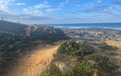
8-day hiking trip Rota Vicentina: the Fishermans trail with local specialist Self-guided, fully taken care of by a local specialist: Fishermen's Trail from Cercal to Odeceixe On day five you board a boat to cross the mouth of the Mira River. No bridge, no timetabled...
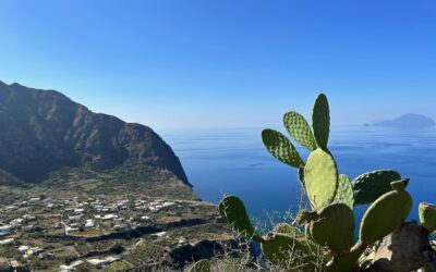
Hiking across smoking volcanoes: an organized hiking tour of the Aeolian Islands On Vulcano, you know you’ve arrived before you even set foot on shore. The sulfur already hangs over the harbor. A smell that hovers somewhere between a match and a boiled egg—and one you...
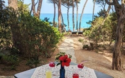
Sleeping in nature in Sardinia: handpicked accommodations, booked directly with the owner A unique place to stay in Sardinia. No nameplate on the door, no reception desk. Instead, an owner who pours you a glass of local wine upon arrival and tells you which trail is...
Get inspired
Are you looking for the most beautiful hiking and biking routes? Or do you want information about traveling by train or advice for the most beautiful road trips through nature. Get inspired for your next trip in green; ideas for planning your own trip or opting for an organized trip.